Welcome to BigEyeInTheSky.com
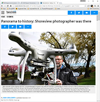
I'm Ed Fink, these are my 360 degree panoramas. I was the first photographer in the world to shoot 360 degree panoramas from a helicopter. Today I'm a FAA licensed drone pilot and shoot most of my aerials with a quadcopter.
In addition to shooting aerial panoramas, I'm also a Google Street View Trusted Photographer in Minneapolis shooting Street View tours inside local businesses.
I publish thousands of 360 degree panoramas and virtual tours to Google Maps, where I currently have over 100 MILLION VIEWS.
Ask me for more information or an estimate for your business!
Facebook - BigEyeInTheSky360
Google Maps - Ed Fink


VISITOR COMMENTS:
"That's the coolest thing on the web."
"You brought tears to my eyes."
"Mind blowing."
"One of the neatest photo sites I've ever seen."
"I'm afraid of heights and when I looked straight down I nearly threw up!"
"I am stunned by the quality and possible applications, nice job."
"That combo of eye-in-the-sky with eyes on the ground is fantastic."
"I sent this to every pilot I know."
"HOW IS THIS EVEN POSSIBLE?!"
"The 360 shots are almost unbelieveable!!!!"
"Oh my gosh Ed - they are just beautiful."
"That aerial panorama over Lake Calhoun is totally awesome"
"FANTASTIC!!!!"
"I've instantly become a fan of your panorama photos!"
"Wow, your panoramas are like nothing I have ever seen before. Very impressive!"
"the absolute best I have seen anywhere."
"ED - I am not surprised by all the comments you have received. The VR is AWESOME!"


Select a panorama category:
 360 degree aerial panorama above Abbott near I-35E and Hwy. 36 in Little Canada, MN.
Equipment: DJI Air2s, 22 mm
Categories: Industrial, Quadcopter, Roseville
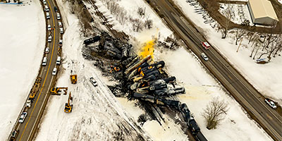
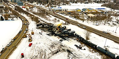
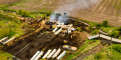
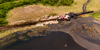 360 degree aerial panorama above Goose Lake in Albert Lea, MN after a train derailment.
Equipment: DJI P4P, 24 mm
Categories: Industrial, Outstate Minnesota, Quadcopter, Railroads
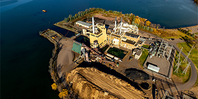 360 degree aerial panorama at Xcel Bay Front BIOMASS Power Plant on the shore of Chequamegon Bay in Ashland, WI.
Equipment: DJI Air2s, 22 mm
Categories: Duluth, Industrial, Quadcopter, Wisconsin
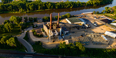
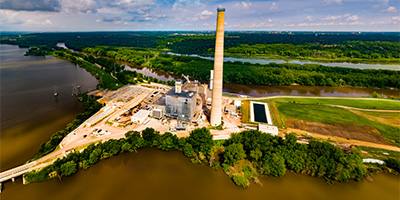 360 degree panorama of the Black Dog Generating Plant on the Minnesota River in Burnsville, MN.
Equipment: DJI P4P, 24 mm
Categories: Industrial, Minnesota River, Quadcopter
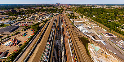 360 degree aerial panorama over the BNSF Midway Railroad Yard in South St. Anthony between Minneapolis and St. Paul.
Equipment: DJI P4P, 24 mm
Categories: Industrial, Minneapolis, Quadcopter, Railroads
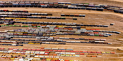 360 degree aerial panorama directly over the BNSF Northtown Railroad Yard in Columbia Heights, just north of Minneapolis.
Equipment: DJI P4P, 24 mm
Categories: Industrial, Minneapolis, Quadcopter, Railroads
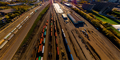 360 degree aerial panorama over the BNSF Bridal Veil Railroad Yard Minneapolis, MN.
Equipment: DJI P4P, 24 mm
Categories: Industrial, Minneapolis, Quadcopter, Railroads
 360 degree aerial panorama above Riverfront Park in Chippewa Falls, WI.
Equipment: DJI P4P, 24 mm
Categories: Eau Claire OLD, Industrial, Quadcopter
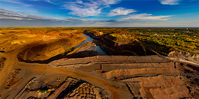
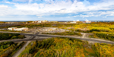
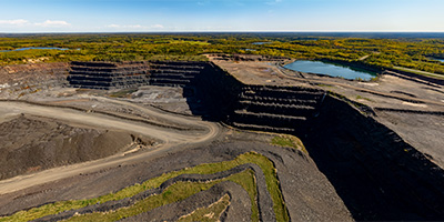 360 degree aerial panorama over an open-pit iron mine owned by Cleveland-Cliffs north of Gilbert, MN.
Equipment: DJI Air2s, 22 mm
Categories: Industrial, Iron Range, Quadcopter
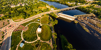
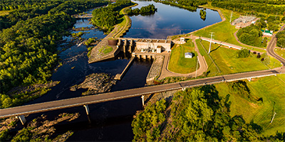
 Over the Mississippi River at Coon_Rapids_Dam.
Equipment: DJI P4P, 24 mm
Categories: Industrial, Mississippi River, Quadcopter
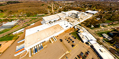 Aerial panorama over the Nestle factory in Eau Claire, WI
Equipment: DJI P3A, 20 mm
Categories: Eau Claire OLD, Industrial, Quadcopter, Wisconsin
 Granite Falls and Minnesota River 360 degree aerial panorama in Granite Falls, MN.
Equipment: DJI P4P, 24 mm
Categories: Industrial, Minnesota River, Outstate Minnesota, Quadcopter
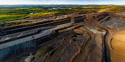
 360 degree aerial panorama over the Hill of Three Waters north of Hibbing, MN. This is one of five intersections of continental divides in the U.S., where water drains to three different watersheds. This is the intersection of the Northern Divide with the St. Lawrence Seaway Divide. From this point water flows north to the Hudson Bay, south to the Gulf of Mexico, and east to the Gulf of St. Lawrence. Chippewa Indians held important council meetings here at "The Top of the World".
Now this is the HullRustMahoning Open Pit Iron Mine, which is the largest open-pit iron mine in the world, stretching over three miles long, two miles wide, and 535 feet deep.
360 degree aerial panorama over the Hill of Three Waters north of Hibbing, MN. This is one of five intersections of continental divides in the U.S., where water drains to three different watersheds. This is the intersection of the Northern Divide with the St. Lawrence Seaway Divide. From this point water flows north to the Hudson Bay, south to the Gulf of Mexico, and east to the Gulf of St. Lawrence. Chippewa Indians held important council meetings here at "The Top of the World".
Now this is the HullRustMahoning Open Pit Iron Mine, which is the largest open-pit iron mine in the world, stretching over three miles long, two miles wide, and 535 feet deep.
Equipment: DJI Air2s, 22 mm
Categories: Featured, Industrial, Iron Range, Quadcopter
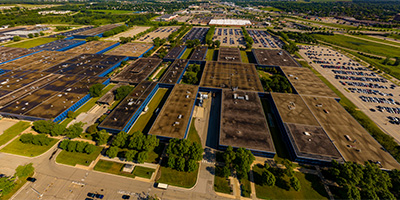 360 degree aerial panorama above the IBM factory in Rochester, MN. When I first moved to Minneapolis in 1988 I interviewed for a programming job on the new AS/400 midrange computer which was manufactured at this factory.
Equipment: DJI P4P, 24 mm
Categories: Industrial, Quadcopter, Rochester
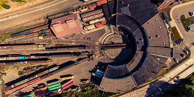 360 degree aerial panorama over the Jackson Street Roundhouse, which is the headquarters for the Minnesota Transportation Museum in St. Paul, MN and a working railroad roundhouse, one of the last of its kind in the country. Built in 1907 to replace an older roundhouse, the site has been used for rail transportation since the first railroad came to Minnesota in the 1860s.
Equipment: DJI P4P, 24 mm
Categories: Industrial, Quadcopter, Railroads, Saint Paul
 360 degree aerial panorama of Jim Falls, WI.
Equipment: DJI P4P, 24 mm
Categories: Eau Claire OLD, Industrial, Quadcopter
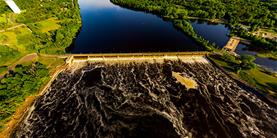
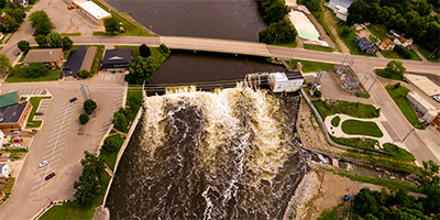
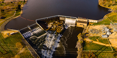 Above the Lake Byllesby Dam on the Cannon River near Cannon Falls, Minnesota.
Equipment: DJI P4P, 24 mm
Categories: Industrial, Outstate Minnesota, Quadcopter
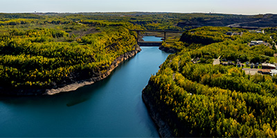
 360 degree aerial panorama of Lake Wissota Hydroelectric Plant, Chippewa Falls, WI.
Equipment: DJI P4P, 24 mm
Categories: Eau Claire OLD, Industrial, Quadcopter
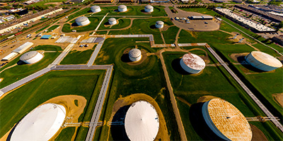 Above the Magellan Pipeline/Tank Farm in Roseville, MN.
Equipment: DJI P4P, 24 mm
Categories: Industrial, Quadcopter
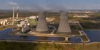 360 degree aerial panorama next to a power plant outside Orlando, Florida.
Equipment: Nikon D70s, Sigma 8mm
Helicopter: WFTV Skywitness News
Pilot: Gregg Beck
Categories: Industrial, Orlando
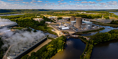 360 degree aerial panorama of the Prairie Island Nuclear Generating Plant near Red Wing, MN. This was my submission for the World Wide Panorama Equinox 2022 Climate Change theme. My first choice was to shoot a 360 of the control room interior, but after a month of trying unsuccessfully to get permission from Xcel I finally gave up. Surprisingly, I didn't need ANY permission to shoot from here.
Equipment: DJI Air2s, 22 mm
Categories: Industrial, Mississippi River, Quadcopter, World Wide Panorama
 360 degree aerial panorama from 400' above train derailment site in Raymond, MN.
Equipment: DJI Air2s, 22 mm
Categories: Industrial, Quadcopter, Railroads
 360 degree aerial panorama from 180' above train derailment site in Raymond, MN.
Equipment: DJI Air2s, 22 mm
Categories: Industrial, Quadcopter, Railroads
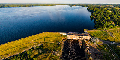
 360 degree aerial panorama near Barn Bluff above the Xcel Generating Plant, which powers 50% of the homes in Red Wing, MN.
Equipment: DJI P4P, 24 mm
Categories: Industrial, Mississippi River, Quadcopter
 360 degree aerial panorama over the Rouchleau Mine, east of Virginia, MN. The abandonded mine is now the source of Virginia Minnesota's drinking water.
Equipment: DJI Air2s, 22 mm
Categories: Industrial, Iron Range, Quadcopter
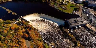 360 degree aerial panorama of Saint Croix Falls Dam in Saint Croix Falls, WI / Taylors Falls, MN.
Equipment: DJI P3A, 20 mm
Categories: Industrial, St Croix River, Wisconsin
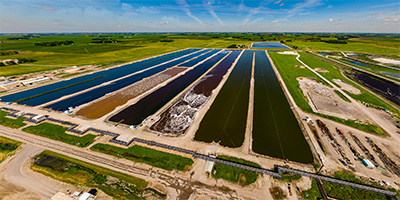 360 degree aerial panorama above the Southern Minnesota Beet Sugar Cooperative in Renville, MN.
Equipment: DJI P4P, 24 mm
Categories: Industrial, Outstate Minnesota, Quadcopter
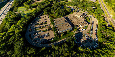
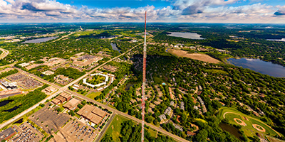 360 degree aerial panorama at the Telefarm Towers in Shoreview, MN. These are 1436' transmission towers for Twin Cities television stations WCCO, KSTP, KARE, and many radio stations. The towers were replacements for a tower that collapsed in 1971, killing six workers on the tower and one on the ground.
This is the highest altitude quadcopter aerial I've done so far. (It's also higher than all but one of my helicopter panoramas!) Normally 400' is the max alititude for a drone, but the FAA allows flights up to 400' HIGHER than nearby structures.
360 degree aerial panorama at the Telefarm Towers in Shoreview, MN. These are 1436' transmission towers for Twin Cities television stations WCCO, KSTP, KARE, and many radio stations. The towers were replacements for a tower that collapsed in 1971, killing six workers on the tower and one on the ground.
This is the highest altitude quadcopter aerial I've done so far. (It's also higher than all but one of my helicopter panoramas!) Normally 400' is the max alititude for a drone, but the FAA allows flights up to 400' HIGHER than nearby structures.
Equipment: DJI P4P, 24 mm
Categories: Industrial, Quadcopter, Shoreview
 360 degree aerial panorama above Otter Creek in Sibley, Iowa after a train derailment.
Equipment: DJI P4P, 24 mm
Categories: Industrial, Iowa, Quadcopter, Railroads
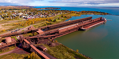 360 degree aerial panorama of the Iron Ore docks on Lake Superior's Agate Bay in Two Harbors, MN. The steel docks were originally built to load high grade iron ore from the Mesabi Iron Range onto large ships, but after World War II most of the high grade iron ore in the U.S. ran out and the industry moved to a lower grade ore, taconite, which you see here. The docks are over 1,300 feet long and seven stories tall. Today 12 million tons of taconite a year are shipped from Two Harbors to other locations on the Great Lakes eventually to be heated up to over 1000 degrees in blast furnaces, and converted into steel.
Equipment: DJI P4P, 24 mm
Categories: Duluth, Industrial, Outstate Minnesota, Quadcopter, World Wide Panorama
 360 degree aerial panorama over the United Taconite Mine in Eveleth, MN.
Equipment: DJI Air2s, 22 mm
Categories: Industrial, Iron Range, Quadcopter
 360 degree aerial panorama over US Steel Minntac in Mountain Iron, MN. Mountain Iron is the location of the first iron discovered in the area and helped make Minnesota the nations's largest iron producer and the United States the world's largest steel manufacturer.
Equipment: DJI Air2s, 22 mm
Categories: Industrial, Iron Range, Quadcopter
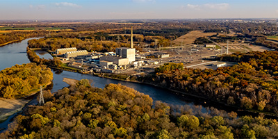 360 degree aerial panorama near the Xcel Monticello Nuclear Generating Plant along the Mississippi River in Monticello, MN
Equipment: DJI Air2s, 22 mm
Categories: Industrial, Mississippi River, Quadcopter, Saint Cloud

Start with the "Featured" category to see an assortment of my most interesting panoramas.