Welcome to BigEyeInTheSky.com
I'm Ed Fink, these are my 360 degree panoramas. I was the first photographer in the world to shoot 360 degree panoramas from a helicopter. Today I'm a FAA licensed drone pilot and shoot most of my aerials with a quadcopter.
In addition to shooting aerial panoramas, I'm also a Google Street View Trusted Photographer in Minneapolis shooting Street View tours inside local businesses.
I publish thousands of 360 degree panoramas and virtual tours to Google Maps, where I currently have over 100 MILLION VIEWS.
Ask me for more information or an estimate for your business!
Facebook - BigEyeInTheSky360
Google Maps - Ed Fink


VISITOR COMMENTS:
"That's the coolest thing on the web."
"You brought tears to my eyes."
"Mind blowing."
"One of the neatest photo sites I've ever seen."
"I'm afraid of heights and when I looked straight down I nearly threw up!"
"I am stunned by the quality and possible applications, nice job."
"That combo of eye-in-the-sky with eyes on the ground is fantastic."
"I sent this to every pilot I know."
"HOW IS THIS EVEN POSSIBLE?!"
"The 360 shots are almost unbelieveable!!!!"
"Oh my gosh Ed - they are just beautiful."
"That aerial panorama over Lake Calhoun is totally awesome"
"FANTASTIC!!!!"
"I've instantly become a fan of your panorama photos!"
"Wow, your panoramas are like nothing I have ever seen before. Very impressive!"
"the absolute best I have seen anywhere."
"ED - I am not surprised by all the comments you have received. The VR is AWESOME!"


Select a panorama category:
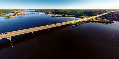 360 degree aerial panorama over the St. Croix River at the I-94 bridge in Hudson, WI.
Equipment: DJI P4P, 24 mm
Categories: Quadcopter, St Croix River, Wisconsin
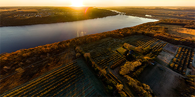
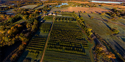
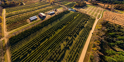 360 degree aerial panorama during sunrise over Afton Apple Orchard near the St. Croix River.
Equipment: DJI P4P, 24 mm
Categories: Apple Orchards, Quadcopter, St Croix River
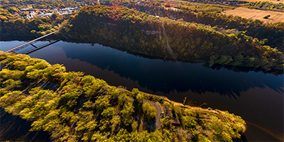
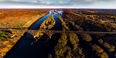 Sunrise at the Arcola High Bridge over the Saint Croix River.
Equipment: DJI P4P, 24 mm
Categories: Bridges, Featured, Quadcopter, St Croix River
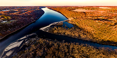 360 degree aerial panorama during sunset at the confluence of the St. Croix and Kinnickinnic rivers on the border of Minnesota and Wisconsin.
Equipment: DJI P4P, 24 mm
Categories: Quadcopter, St Croix River, Wisconsin
 Fairy Falls sunrise 360 degree aerial panorama north of Stillwater, MN.
Equipment: DJI P4P, 24 mm
Categories: Quadcopter, St Croix River, Stillwater, World Wide Panorama
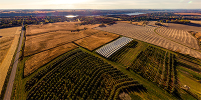
 360 degree aerial panorama over Fischer Croix Farm Orchard on the banks of the St. Croix River in Hastings, MN. Downstream to the south you can see the confluence of the St. Croix and Mississippi Rivers. In the distance to the southwest you can see the new Hastings Mississippi River Bridge and Ardent Mills on the bank of the Vermillion River.
Equipment: DJI P4P, 24 mm
Categories: Apple Orchards, Quadcopter, St Croix River
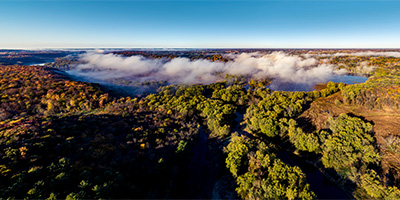 360 degree aerial panorama over a foggy St. Croix River Valley north of Osceola, WI.
Equipment: DJI P4P, 24 mm
Categories: Quadcopter, St Croix River, Wisconsin
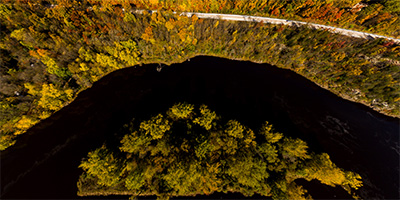 360 degree aerial panorama directly over Folsom Island on the Saint Croix River.
Equipment: DJI P3A, 20 mm
Categories: St Croix River, Wisconsin
 Aerial panorama of Girl Scout Camp Sagata.
Equipment: DJI P3A, 20 mm
Categories: Quadcopter, St Croix River, Stillwater
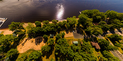
 360 degree aerial panorama over Hudson Lakefront Park in Hudson, WI.
Equipment: DJI P3A, 20 mm
Categories: Quadcopter, St Croix River, Wisconsin
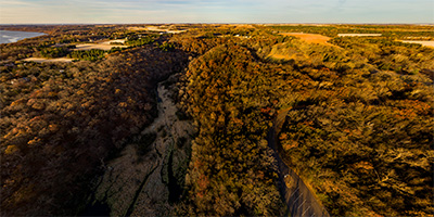
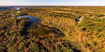
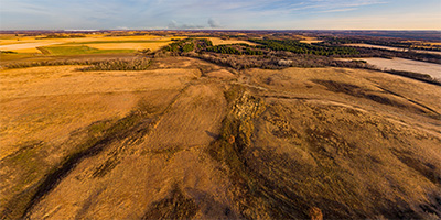 360 degree aerial panorama over Lost Valley Prairie Scientific and Natural Area between the Mississippi River and the St. Croix River in Cottage Grove, MN.
Equipment: DJI P4P, 24 mm
Categories: Quadcopter, St Croix River
 360 degree aerial panorama above McDougalls Apple Junction along the St. Croix River north of Hastings, MN.
Equipment: DJI P4P, 24 mm
Categories: Apple Orchards, Quadcopter, St Croix River
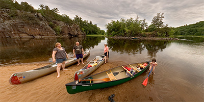
 360 degree aerial panorama over Osceola Landing on the St. Croix River just south of Osceola, WI. We would usually pass this point while canoing and instead of getting out here we'd foolishly keep going to William O'Brien State Park and either miss the last bus back to Taylors Falls or have to paddle like crazy the last couple of miles.
Equipment: DJI P4P, 24 mm
Categories: Quadcopter, St Croix River
 360 degree aerial panorama over Pleasant Valley Orchard near the St. Croix River at Osceola, WI.
Equipment: DJI P4P, 24 mm
Categories: Apple Orchards, Quadcopter, St Croix River, Wisconsin
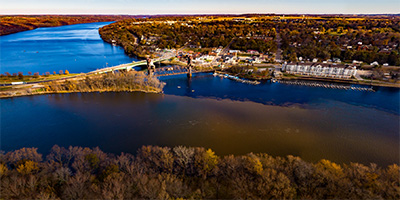 Prescott, Wisconsin, east of Hastings at the confluence of the Saint Croix River and the Mississippi River.
Equipment: DJI P4P, 24 mm
Categories: Mississippi River, Quadcopter, St Croix River
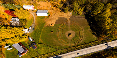 Falls Orchard in Shafer Township, MN, near the St. Croix River.
Equipment: DJI P3A, 20 mm
Categories: Outstate Minnesota, St Croix River
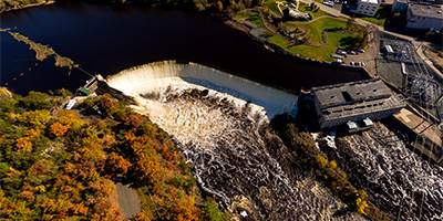 360 degree aerial panorama of Saint Croix Falls Dam in Saint Croix Falls, WI / Taylors Falls, MN.
Equipment: DJI P3A, 20 mm
Categories: Industrial, St Croix River, Wisconsin
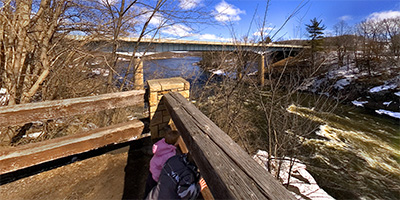 360 degree panorama on the second day of spring as two children take advantage of the warm weather to throw snowballs in the St. Croix River that separates Minnesota and Wisconsin, just south of Taylor’s Falls, MN and St. Croix Falls, WI.
Over the 2006 Spring Equinox VR photographers around the world shot panoramas on the theme "Borders" for the World Wide Panorama. This was my submission.
Equipment: NikonD70, Sigma 8mm, Kaidan QuickPan III
Categories: St Croix River, Wisconsin, World Wide Panorama
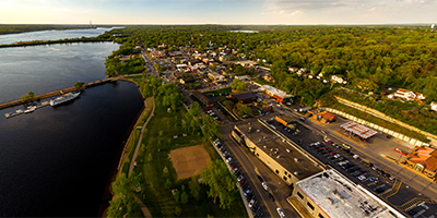
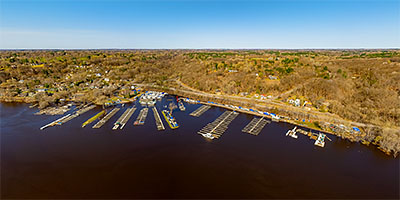
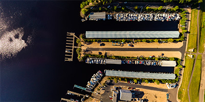
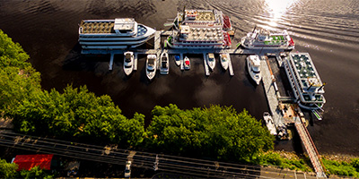 Aerial panorama above Stillwater’s St Croix Boat and Packet Company
Equipment: DJI P3A, 20 mm
Categories: Quadcopter, St Croix River, Stillwater
 360 degree aerial panorama at sunrise over St. Croix Bluffs Regional Park along the St. Croix River betwee Minnesota and Wisconsin.
Equipment: DJI P4P, 24 mm
Categories: Quadcopter, St Croix River
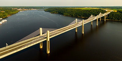 St. Croix Crossing aerial panorama from 380’.
Equipment: DJI P3A, 20 mm
Categories: Bridges, Quadcopter, St Croix River, Stillwater
 360 degree panorama on Sand Island in the St. Croix River between Minnesota and Wisconsin.
This was my submission for the 2009 Summer Solstice World Wide Panorama event.
Equipment: Nikon D70s, Sigma 8mm, Nodal Ninja 3, PocketWizard Plus
Categories: St Croix River, World Wide Panorama
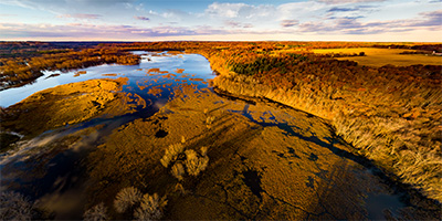
 360 degree aerial panorama of St. Croix River flooding north of Stillwater, MN.
Equipment: DJI Air2s, 22 mm
Categories: Quadcopter, St Croix River, Stillwater
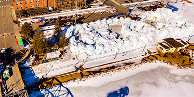 Stillwater Ice Castles 360 degree aerial panorama, from above the old lift bridge.
Equipment: DJI P4P, 24 mm
Categories: Quadcopter, St Croix River, Stillwater, World Wide Panorama
 Sunset at the Apple River/Saint Croix River confluence.
Equipment: DJI P4P, 24 mm
Categories: Apple River, Quadcopter, St Croix River
 Taylors Falls Scenic Boat Tours 360 degree aerial panorama on the St. Croix River dividing Minnesota and Wisconsin.
Equipment: DJI P3A, 20 mm
Categories: St Croix River, Wisconsin
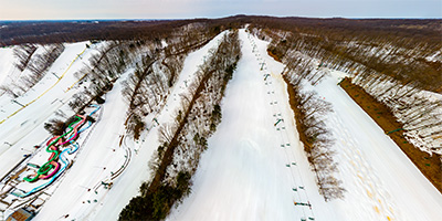 Wild Mountain Chair 3 360 degree aerial panorama
Equipment: DJI P4P, 24 mm
Categories: St Croix River
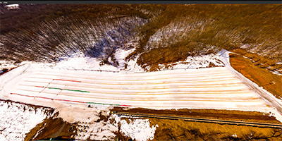
 Wild Mountain Rope Tow 360 degree aerial panorama
Equipment: DJI P4P, 24 mm
Categories: St Croix River
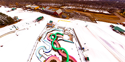
 Wild Mountain Snow Tubing 360 degree aerial panorama
Equipment: DJI P4P, 24 mm
Categories: St Croix River
 360 degree aerial panorama at William O'Brien State Parl along the St. Croix River north of Marine on St. Croix, MN. If you start canoeing at Taylors Falls too late and you don't get out at Osceola Landing, this is where you end up stranded when you miss the bus.
Equipment: DJI P4P, 24 mm
Categories: Quadcopter, St Croix River
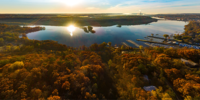
 360 degree aerial panorama during sunrise at Windmill Marina on the St. Croix River in Afton, MN.
Equipment: DJI P4P, 24 mm
Categories: Quadcopter, St Croix River

Start with the "Featured" category to see an assortment of my most interesting panoramas.