Welcome to BigEyeInTheSky.com
I'm Ed Fink, these are my 360 degree panoramas. I was the first photographer in the world to shoot 360 degree panoramas from a helicopter. Today I'm a FAA licensed drone pilot and shoot most of my aerials with a quadcopter.
In addition to shooting aerial panoramas, I'm also a Google Street View Trusted Photographer in Minneapolis shooting Street View tours inside local businesses.
I publish thousands of 360 degree panoramas and virtual tours to Google Maps, where I currently have over 100 MILLION VIEWS.
Ask me for more information or an estimate for your business!
Facebook - BigEyeInTheSky360
Google Maps - Ed Fink


VISITOR COMMENTS:
"That's the coolest thing on the web."
"You brought tears to my eyes."
"Mind blowing."
"One of the neatest photo sites I've ever seen."
"I'm afraid of heights and when I looked straight down I nearly threw up!"
"I am stunned by the quality and possible applications, nice job."
"That combo of eye-in-the-sky with eyes on the ground is fantastic."
"I sent this to every pilot I know."
"HOW IS THIS EVEN POSSIBLE?!"
"The 360 shots are almost unbelieveable!!!!"
"Oh my gosh Ed - they are just beautiful."
"That aerial panorama over Lake Calhoun is totally awesome"
"FANTASTIC!!!!"
"I've instantly become a fan of your panorama photos!"
"Wow, your panoramas are like nothing I have ever seen before. Very impressive!"
"the absolute best I have seen anywhere."
"ED - I am not surprised by all the comments you have received. The VR is AWESOME!"


Select a panorama category:
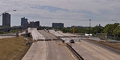
 360 degree aerial panorama west of the new I-35W bridge spanning the Mississippi River in Minneapolis, MN.
Equipment: Nikon D70s, Sigma 8mm, PocketWizard Plus
Categories: 35W Bridge Collapse, Bridges, Mississippi River, WCCO
 360 degree panorama showing the collapsed I-35W bridge from the University of Minnesota’s bikeway bridge over the Mississippi River.
This was shot August 15th, the morning Mayor Rybak ordered the bikeway reopened, but by the afternoon Sheriff Stanek ordered the bikeway closed again.
Equipment: NikonD70, Sigma 8mm, Nodal Ninja 3, PocketWizard Plus
Categories: 35W Bridge Collapse, Bridges, Minneapolis, Mississippi River, University of Minnesota
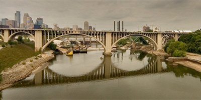
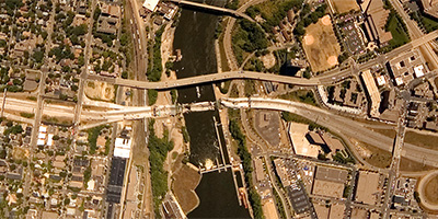
 360 degree aerial panorama over Lock and Dam #1 near the I-35W Mississippi River Bridge in Minneapolis, MN, a few days after the 16th anniversary of the bridge collapse.
Equipment: DJI Air2s, 22 mm
Categories: 35W Bridge Collapse, Bridges, Featured, Minneapolis, Mississippi River, Quadcopter
 360 degree aerial panorama on 2nd St. near the collapsed I-35W.bridge spanning the Mississippi River in Minneapolis, MN.
My 8mm fisheye lens leaves me at a real disadvantage from this far back.
Equipment: NikonD70, Sigma 8mm, Nodal Ninja 3, PocketWizard Plus
Categories: 35W Bridge Collapse, Bridges, Minneapolis, Mississippi River
 360 degree panorama from the University Ave. overpass near the collapsed I-35W.bridge.
Equipment: NikonD70, Sigma 8mm, Nodal Ninja 3, PocketWizard Plus
Categories: 35W Bridge Collapse, Bridges, Minneapolis, Mississippi River
 360 degree aerial panorama over the collapsed I-35W bridge spanning the Mississippi River in Minneapolis, MN.
This was shot the morning after the collapse when there was a TFR (temporary flight restriction) over the bridge, and I had to fly significantly higher than I normally shoot, so you won’t be able to see much detail in the bridge. I may be able to do more at a decent altitude when the TFR is lifted.
Equipment: Nikon D70s, Sigma 8mm, PocketWizard Plus
Helicopter: Davis Aviation
Pilot: Joanne Boyer
Categories: 35W Bridge Collapse, Bridges, Minneapolis, Mississippi River
 360 degree aerial panorama overlooking the collapsed I-35W bridge from the middle of the 10th Ave. Mississippi River bridge in Minneapolis, MN.
This was a month after the collapse, and the second day the 10th Ave. bridge was open to traffic.
Equipment: NikonD70, Sigma 8mm, Nodal Ninja 3, PocketWizard Plus
Categories: 35W Bridge Collapse
 360 degree aerial panorama overlooking the collapsed I-35W bridge from the north end of the 10th Ave. Mississippi River bridge in Minneapolis, MN.
This was a month after the collapse, and the second day the 10th Ave. bridge was open to traffic.
Equipment: NikonD70, Sigma 8mm, Nodal Ninja 3, PocketWizard Plus
Categories: 35W Bridge Collapse
 360 degree aerial panorama overlooking the collapsed I-35W bridge from the south end of the 10th Ave. Mississippi River bridge in Minneapolis, MN.
This was a month after the collapse, and the second day the 10th Ave. bridge was open to traffic.
Equipment: NikonD70, Sigma 8mm, Nodal Ninja 3, PocketWizard Plus
Categories: 35W Bridge Collapse
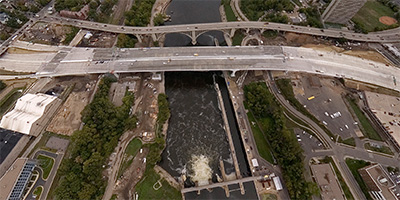
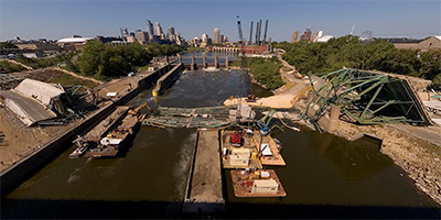
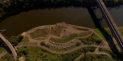
 360 degree aerial panorama directly over Gold Medal Park overlooking the Mississippi River in downtown Minnespolis, MN. The river has been drawn down to record levels to inspect the locks, exposing the river bottom in places, the exposed foot of St. Anthony Falls, and remains of older river structures.
Equipment: DJI P4P, 24 mm
Categories: 35W Bridge Collapse, Minneapolis, Mississippi River, Quadcopter, World Wide Panorama
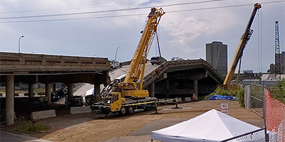
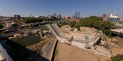
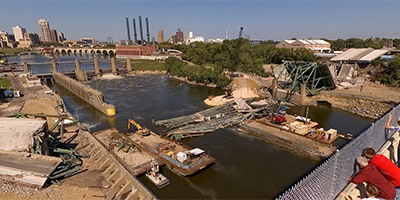
 360 degree aerial panorama over the I-35W Bridge Collapse Investigation Site across from the University of Minnesota.
Girders from the collapsed bridge are moved by barge to here and laid out for the engineers and inspectors to study.
Equipment: Nikon D70s, Sigma 8mm, PocketWizard Plus
Helicopter: Davis Aviation
Pilot: Mark Boyer
Categories: 35W Bridge Collapse, Mississippi River
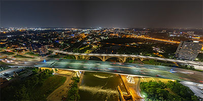
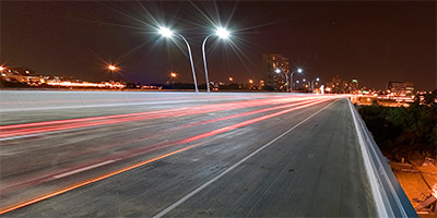 360 degree panorama at night from the I-35W Mississippi River Bridge in Minneapolis, Minnesota. This was shot the first weekend after the bridge was complete. When I started setting up, the river boat had just entered the Lower Saint Anthony Lock from downstream, and by the time I was finished shooting the lock had filled and the boat was leaving.
Don’t try shooting here yourself! A lady cop showed up just as I finished and she wrote me a ticket and gave me an angry 20 minute pedestrian safety lecture. You don’t want to run into her - she’s kind of "excitable". Any other cop would have ignored me, or calmly said "You’re not allowed to walk on the bridge, move on please." No - this cop doesn’t know the meaning of calm. She was almost hysterical, SCREAMING: "WHAT THE HELL DO YOU THINK YOU’RE DOING??!! WHO THE HELL DO YOU THINK YOU ARE???!! YOU’RE CRAZY!!!! YOU’RE OUT OF YOUR MIND!!!! WHAT AN IDIOT!!!! NOW I HAVE TO WASTE MY TIME WRITING YOU A CITATION!!"
I’ve got a bad knee, and as I was struggling to get out of her back seat with all my equipment, she started screaming again: "HURRY UP SIR! COME ON NOW!!! I DON"T HAVE ALL NIGHT!! GET!!! OUT!!!!"
I was hoping she’d just yell and not give me a ticket (no such luck!), so I was super polite to her. If that’s the way she treats a quiet, polite, professional photographer over twice her age, she must be hell on REAL criminals, like jaywalkers and litterbugs!!
Maybe she thought if she screamed enough she could "get through to me" and one day I would thank her for making me a better pedestrian? Yawn
not likely. I’ve done things FAR stupider than walking on a bridge. :)
Equipment: Nikon D70s, Sigma 8mm, Nodal Ninja 3, PocketWizard Plus
Categories: 35W Bridge Collapse, Bridges, Minneapolis, Mississippi River
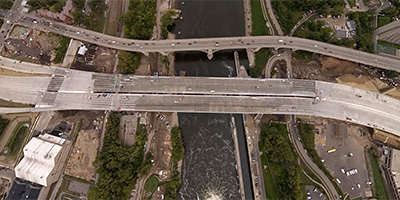 360 degree aerial panorama over new I-35W bridge spanning the Mississippi River in Minneapolis, MN.
Equipment: Nikon D70s, Sigma 8mm, PocketWizard Plus
Categories: 35W Bridge Collapse, Bridges, Mississippi River, WCCO
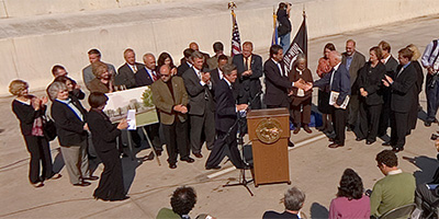 360 degree panorama of the press conference to announce the completion of the Saint Anthony Falls I-35W bridge Minneapolis, Minnesota. Speakers include U. S. Secretary of Transportation Mary Peters, Minnesota Governor Tim Pawlenty, Mayor R.T. Rybak, Senator Norm Coleman, Senator Amy Klobuchar, Congressman Tim Walz, Congressman John Kline, Congresswoman Betty McCollum, Congressman Keith Ellison, Congresswoman Michelle Bachmann, and Congressman James Oberstar.
Equipment: Nikon D70s, Sigma 8mm, Nodal Ninja 3 on 10' pole, PocketWizard Plus
Categories: 35W Bridge Collapse, Bridges, Mississippi River, WCCO

Start with the "Featured" category to see an assortment of my most interesting panoramas.