Welcome to BigEyeInTheSky.com
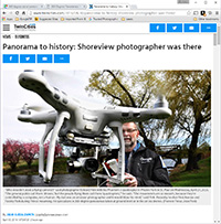
I'm Ed Fink, these are my 360 degree panoramas. I was the first photographer in the world to shoot 360 degree panoramas from a helicopter. Today I'm a FAA licensed drone pilot and shoot most of my aerials with a quadcopter.
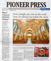
In addition to shooting aerial panoramas, I'm also a Google Street View Trusted Photographer in Minneapolis shooting Street View tours inside local businesses.
I publish thousands of 360 degree panoramas and virtual tours to Google Maps, where I currently have over 100 MILLION VIEWS.
Ask me for more information or an estimate for your business!
Facebook - BigEyeInTheSky360
Google Maps - Ed Fink

VISITOR COMMENTS:
"That's the coolest thing on the web."
"You brought tears to my eyes."
"Mind blowing."
"One of the neatest photo sites I've ever seen."
"I'm afraid of heights and when I looked straight down I nearly threw up!"
"I am stunned by the quality and possible applications, nice job."
"That combo of eye-in-the-sky with eyes on the ground is fantastic."
"I sent this to every pilot I know."
"HOW IS THIS EVEN POSSIBLE?!"
"The 360 shots are almost unbelieveable!!!!"
"Oh my gosh Ed - they are just beautiful."
"That aerial panorama over Lake Calhoun is totally awesome"
"FANTASTIC!!!!"
"I've instantly become a fan of your panorama photos!"
"Wow, your panoramas are like nothing I have ever seen before. Very impressive!"
"the absolute best I have seen anywhere."
"ED - I am not surprised by all the comments you have received. The VR is AWESOME!"


Select a panorama category:
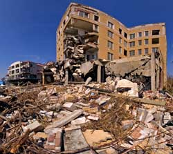
This is a series of 360 degree panoramas that I shot for the Washington Post after Hurricane Katrina. It includes aerials of Biloxi, Gulfport, Long Beach, Pass Christian, Waveland, Slidell, Chalmette, and New Orleans.
The aerials east of Pass Christian were shot about three weeks after Hurricane Katrina and three days before Hurricane Rita, and everything from Waveland west to New Orleans was shot three days after Rita, which caused additional flooding (or re-flooding) in Chalmette and the Ninth Ward.
My Hurricane Camille experience is what compelled me to return to Gulfport after Katrina to shoot these 360 degree panoramas.
Although Ive lived in Minneapolis sincr 1988, in 1969 I was 16 years old living a few blocks from the beach in Gulfport when Hurricane Camille hit. My dad was in Vietnam so I was the man of the house, and I scoffed at the idea of evacuating. I told a friend "Dont worry, if the hurricane really starts to get bad Ill get my mom and sister in the car and drive north." He laughed at me, said I was an idiot and didn’t understand what was coming. He was right. We spent the night huddled in the hallway listening to the trees snapping in half, falling all around us and on the house. There would be no "driving north" - the first big tree that fell blocked the driveway. Blocked it so bad it took my lazy teenage butt three days to chop it in half with my dull axe. Not that it mattered, most streets were blocked by something - trees, roofs, boats, giant oil tanks, telephone poles, cars, ocean going ships, etc. The water got deep enough to flood our washer and dryer in the carport, but didn't get in the house. I walked around the yard during the eye of the storm until my mom freaked out and thought I was going to suddenly get sucked up into the sky when the direction changed.
At daybreak I was stunned by what I saw. Most of the homes and stores along the beach were totally destroyed. I hope the family at the end of our street at Hwy. 90 and Fournier Ave. evacuated. Their house wasnt just destroyed it literally disappeared, along with the land it stood on and a large part of the highway in front of it. It was like a bomb had gone off.
After the roads were cleared the schools were still closed, so I got a temporary job at the Tri-County Mosquito Control Commission and rode around in a jeep filled with tanks of malthion mixed with sugar, spraying for flies. I went home every night with my clothes soaked in sugary poison. I saw all the Camille destruction up close because of my job, which gave me access everywhere, even with martial law. I had a work pass that would let me out before and after curfew, enter restricted areas, and allowed me to drive over the damaged Bay St. Louis bridge instead of driving 30 miles around it. I worked all three coastal counties, climbing over the rubble of demolished homes spraying refrigerators and freezers, aisle after aisle in wrecked grocery stores, every restaurant on the coast from Biloxi to Bay St. Louis, and the many fish and cat food processors on the gulf. It was an incredibly nasty job, but it sure gave me the grand tour of the Camille damage!
Watching the Katrina devastation on TV brought back so many memories of Hurricane Camille that I had to go shoot the damage, and luckily I was able to convince the Washington Post to fund my trip.
My friend Steve Townsend, who survived both Camille and Katrina, wrote the song Killer Katrina about his experiences
 360 degree aerial panorama 700 ft. above the beach in east Biloxi, MS after Hurricane Katrina. Although the new, larger hotels survived the hurricane, the casino barges were torn free and destroyed everything in their path.
Looking 5 blocks west down the beach you can see one of the smaller casino barges sitting on the lawn of the historic Tivoli Hotel (where I once worked!) The two story motel section in front of the hotel was struck by the barge, completely leveling it and killing 8 people, and a 4 story chunk was knocked out of the front of the hotel.
Equipment: NikonD70, Sigma 8mm
Helicopter: J. W. Fordham (318)547-4109
Pilot: J. W. Fordham (318)547-4109
Categories: Featured, Hurricane Katrina, World Wide Panorama
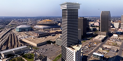 Aerial panorama of downtown New Orleans and the Superdome from a helicopter 400 ft. above the Pontchartrain Expressway at Baronne St. This was shot almost a month after Hurricane Katrina and three days after Hurricane Rita, which accounts for the eerie look of the almost empty streets and highways. The Greater New Orleans Mississippi River Bridge is normally the fifth busiest toll bridge in the U.S.
(My tale of an earlier disaster - the May 3, 1978 flood: I lived on the west bank and by the time I woke up my car was half submerged. I walked from Gretna to Algiers to check on friends, wading through chest deep water at times, and occasionally even swimming down the street. At General De Gaulle Dr. I caught a ride on a semi, standing outside on the steps to the driver’s door. Eventually I had to walk again when the truck stalled and couldn’t be restarted with the batteries under water.)
Equipment: NikonD70, Sigma 8mm
Helicopter: Panther Helicopters
Pilot: Lance Panepinto
Categories: Featured, Hurricane Katrina
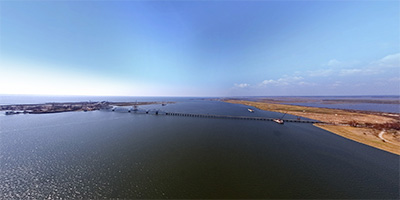
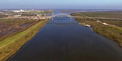
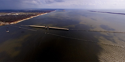 360 degree aerial panorama over the bay on the Biloxi-Ocean Springs Bridge on Hwy. 90.
Equipment: NikonD70, Sigma 8mm
Helicopter: J. W. Fordham (318)547-4109
Pilot: J. W. Fordham (318)547-4109
Categories: Hurricane Katrina
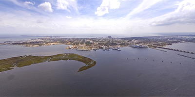 360 degree panorama from 700 ft. over the Biloxi Back Bay after Hurricane Katrina. To the south is Biloxi, then the Gulf of Mexico, to the north is D’Iberville. To southeast are the ruins of two Biloxi-Ocean Springs bridges - one destroyed by Hurricane Camille in 1969 and the other by Katrina. In the distance over Ocean Springs is a rain cloud from the fringes of the approaching Hurricane Rita.
Equipment: NikonD70, Sigma 8mm, Kaidan QuickPan III
Helicopter: J. W. Fordham (318)547-4109
Pilot: J. W. Fordham (318)547-4109
Categories: Hurricane Katrina
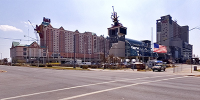
 360 degree aerial panorama above downtown Biloxi over the Vieux Marche a month after Hurricane Katrina. To the south the Hard Rock Casino and Beau Rivage sit on the shore of the Mississippi Sound.
Equipment: NikonD70, Sigma 8mm
Helicopter: J. W. Fordham (318)547-4109
Pilot: J. W. Fordham (318)547-4109
Categories: Hurricane Katrina
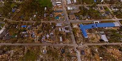
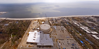 360 degree aerial panorama from a helicopter over Beauvoir (the home and presidential library of Confederate President Jefferson Davis) and the Mississippi Coast Coliseum and Convention Center in Biloxi. The casino barge north of the beach is sitting on a Holiday Inn. A few miles to the north is the damaged Popps Ferry bridge over the back bay.
Equipment: NikonD70, Sigma 8mm
Helicopter: J. W. Fordham (318)547-4109
Pilot: J. W. Fordham (318)547-4109
Categories: Hurricane Katrina
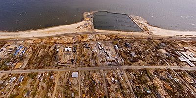
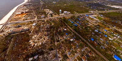 360 degree aerial panorama shot from a helicopter 700 feet over the coast east of the rubble that once was the Fun Time USA amusement park on Hwy. 90 and Cowan Rd. in Gulfport, Mississippi after Hurricane Katrina.
Equipment: NikonD70, Sigma 8mm
Helicopter: J. W. Fordham (318)547-4109
Pilot: J. W. Fordham (318)547-4109
Categories: Hurricane Katrina
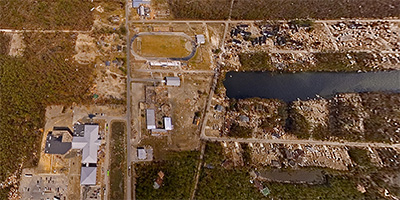
 360 degree panorama from a helicopter just north of what remains of the Water’s Edge Apartments on Hwy. 90 near Courthouse Rd. in Gulfport, Mississippi after Hurricane Katrina. To the northeast is the Gulfport-Biloxi airport.
Equipment: NikonD70, Sigma 8mm
Helicopter: J. W. Fordham (318)547-4109
Pilot: J. W. Fordham (318)547-4109
Categories: Hurricane Katrina
 360 degree aerial panorama one block northwest of Pass Rd. and Hwy. 49 in north Gulfport, Mississippi after Hurricane Katrina. To the northeast is the Gulfport-Biloxi airport, to the west is the Naval Construction Battalion Center (Seabee Base).
Equipment: NikonD70, Sigma 8mm
Helicopter: J. W. Fordham (318)547-4109
Pilot: J. W. Fordham (318)547-4109
Categories: Hurricane Katrina
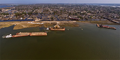
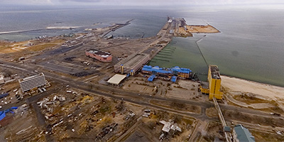 Aerial panorama over the Grand Casino Oasis Hotel on Hwy. 90 west of downtown Gulfport, Mississippi after Hurricane Katrina. To the southwest is the Gulfport Harbor, where you see the huge pink Copa Casino barge sitting in the parking lot that’s usually filled with trucks waiting to load bananas at the port. The blurry spots are raindrops from the fringes of the approaching Hurricane Rita.
Equipment: NikonD70, Sigma 8mm
Helicopter: J. W. Fordham (318)547-4109
Pilot: J. W. Fordham (318)547-4109
Categories: Hurricane Katrina
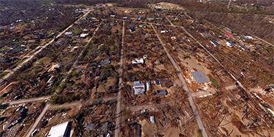
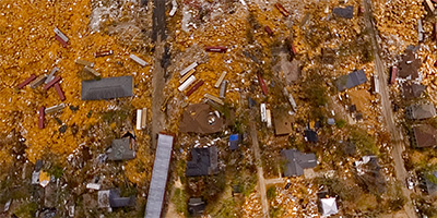 360 degree panorama of Gulfport, Mississippi from a helicopter 700 ft. over Hwy. 90 near Broad Ave., the main road to the Naval Construction Battalion Center (Seabee Base). Although I wasn’t there for Hurricane Katrina, during Hurricane Camille in 1969 I lived on Fournier Ave. Camille was my first hurricane and I didn’t think there was any need to evacuate - until trees started falling on the house! But by then it was too late - the street to the north was totally blocked, and to the south Hwy. 90 was literally gone. A friend from school lived on the corner where the big office building is now, and his entire house was destroyed by Camille - just like almost every other house along the beach as far as the eye could see - very much like it looks in this panorama.
Although Katrina was a weaker storm than Camille, it lasted much longer, and the Katrina damage seems very similar to that from Camille.
Note the many containers washed up from the Port of Gulfport. The containers did a great deal of damage and are the subject of a lawsuit against the port.
Equipment: NikonD70, Sigma 8mm
Helicopter: J. W. Fordham (318)547-4109
Pilot: J. W. Fordham (318)547-4109
Categories: Hurricane Katrina
 Aerial panorama of Long Beach, Mississippi from a helicopter over East Railroad St. at Richards Ave. after Hurricane Katrina.
Equipment: NikonD70, Sigma 8mm
Helicopter: J. W. Fordham (318)547-4109
Pilot: J. W. Fordham (318)547-4109
Categories: Hurricane Katrina
 A 360 degree aerial panorama of downtown Long Beach, Mississippi from a helicopter 700’ above Jeff Davis Ave. after Hurricane Katrina.
Equipment: NikonD70, Sigma 8mm
Helicopter: J. W. Fordham (318)547-4109
Pilot: J. W. Fordham (318)547-4109
Categories: Hurricane Katrina
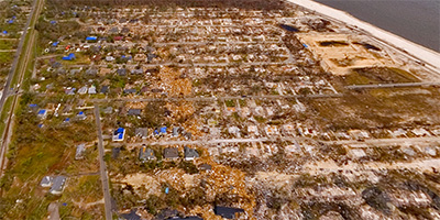 Aerial panorama 700 ft. over the Long Beach - Pass Christian line near the railroad tracks three weeks after Hurricane Katrina struck the Mississippi Gulf Coast.
Equipment: NikonD70, Sigma 8mm
Helicopter: J. W. Fordham (318)547-4109
Pilot: J. W. Fordham (318)547-4109
Categories: Hurricane Katrina
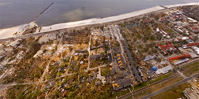
 A 360 degree aerial panorama from a helicopter over a devastated downtown Pass Christian, Mississippi after Hurricane Katrina.
Equipment: NikonD70, Sigma 8mm
Helicopter: J. W. Fordham (318)547-4109
Pilot: J. W. Fordham (318)547-4109
Categories: Hurricane Katrina
 360 degree aerial panorama shot from a helicopter 700 feet over Pass Christian High School in Pass Christian, Mississippi after Hurricane Katrina.
Equipment: NikonD70, Sigma 8mm
Helicopter: J. W. Fordham (318)547-4109
Pilot: J. W. Fordham (318)547-4109
Categories: Hurricane Katrina
 360 degree aerial panorama of the St. Louis Bay shot from a helicopter 700 feet above Pass Christian Isles in Pass Christian, Mississippi after Hurricane Katrina. This is near Henderson Point, just west of the Pass Christian Isles Golf Club. Crossing the bay to the west is the ruins of the Hwy. 90 bridge connecting Pass Christian and Bay St. Louis.
Equipment: NikonD70, Sigma 8mm
Helicopter: Panther Helicopters
Pilot: Lance Panepinto
Categories: Hurricane Katrina
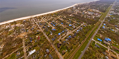
 360 degree aerial panorama shot from a helicopter 400 feet above Waveland, Mississippi after Hurricane Katrina.
Equipment: NikonD70, Sigma 8mm
Helicopter: Panther Helicopters
Pilot: Lance Panepinto
Categories: Hurricane Katrina
 360 degree aerial panorama shot from a helicopter 400 feet above the Rigolets Pass in southern Louisiana after Hurricane Katrina. This is where Lake Pontchatrain connects to Lake Borgne and the Gulf of Mexico.
The U.S. Army Corp of Engineers planned to build hurricane barriers at the Rigolets and Chef Menteur passes to prevent storm surges from reaching Lake Pontchatrain and flooding New Orleans. But in 1977 an environmental group sued because of the possible damage to the area ecosystem.
Equipment: NikonD70, Sigma 8mm
Helicopter: Panther Helicopters
Pilot: Lance Panepinto
Categories: Hurricane Katrina
 360 degree aerial panorama 400 ft. above the lakefront boating community of Grand Lagoon in Slidell, Louisiana after Hurricane Katrina.
Equipment: NikonD70, Sigma 8mm
Helicopter: Panther Helicopters
Pilot: Lance Panepinto
Categories: Hurricane Katrina
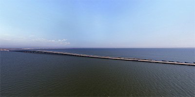 360 degree aerial panorama 400’ above Lake Pontchartrain north of the I-10 Twin Spans that connected New Orleans and Slidell - until destroyed by Hurricane Katrina.
Equipment: NikonD70, Sigma 8mm
Helicopter: Panther Helicopters
Pilot: Lance Panepinto
Categories: Hurricane Katrina
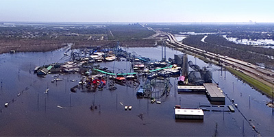 360 degree aerial panorama 400’ above the Six Flags Amusement Park between Slidell and New Orleans after Hurricane Katrina. This flooding may have been from Hurricane Rita, which struck three days before this photo.
Equipment: NikonD70, Sigma 8mm
Helicopter: Panther Helicopters
Pilot: Lance Panepinto
Categories: Hurricane Katrina
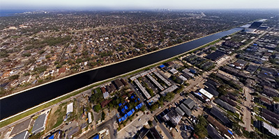
 360 degree aerial panorama 400 feet above the Gulf Intracoastal Waterway in Orleans Parish, Louisiana after Hurricane Katrina. The Paris Rd. bridge is to the west. Beyond the bridge on the left is the NASA Michoud Facility, which manufactures the external fuel tanks for the Space Shuttle. Across the canal to the right you can see where the Mississippi River Gulf Outlet (the MRGO - aka Mister Go) connects to the Gulf Intracoastal Waterway. The storm surge from Hurricane Katrina flowed down this canal to the Industrial Canal, where it met water flowing south from Lake Pontchartrain, and overtopped the east levee, flooding the Ninth Ward and westward to St. Bernard Parish. Note the barges washed up on top of the levee near the base of the bridge.
Equipment: NikonD70, Sigma 8mm
Helicopter: Panther Helicopters
Pilot: Lance Panepinto
Categories: Hurricane Katrina, Mississippi River
 360 degree aerial photograph shoot from a helicopter 400 ft. above a muddy neighborhood in St. Bernard Parish, Louisiana after Hurricane Katrina and three days after Hurricane Rita. This is east of Paris Rd. in Chalmette. To the south is the Mississippi River, and up river to the west you can the New Orleans skyline.
Equipment: NikonD70, Sigma 8mm
Helicopter: Panther Helicopters
Pilot: Lance Panepinto
Categories: Hurricane Katrina, Mississippi River
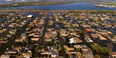 360 degree aerial panorama from a helicopter 400 feet above New Orleans’ flooded Ninth Ward. This is over Charbonnet St. at Miro St., east of the Inner Harbor Navigational Canal (aka Industrial Canal) between the Florida Ave. bridge and the N. Claiborne bridge where the levee was breeched during Hurricane Katrina - and again during Hurricane Rita. To the south is the Mississippi River, and upriver you can see the New Orleans skyline.
Equipment: NikonD70, Sigma 8mm
Helicopter: Panther Helicopters
Pilot: Lance Panepinto
Categories: Hurricane Katrina, Mississippi River
 360 degree aerial photograph of the Inner Harbor Navigation Canal (aka Industrial Canal) from a helicopter 400 feet over the Galvez St. Wharf. This is between the Florida Ave. bridge and the N. Claiborne bridge where the levee to the east was breeched during Hurricane Katrina, flooding the Ninth Ward in Arabi and eastward on to Chalmette in St. Bernard Parish. The flooding shown here is from Hurricane Rita, which hit three days before this photo was taken. To the south is the Mississippi River, and upriver you can see the New Orleans skyline and the Greater New Orleans Bridge. Note Barge ING 4727, which, depending on which theory you subscribe to, was either washed over the levee, or struck the levee and actually caused the breach.
Equipment: NikonD70, Sigma 8mm
Helicopter: Panther Helicopters
Pilot: Lance Panepinto
Categories: Hurricane Katrina, Mississippi River
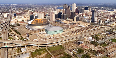 Aerial panorama near the New Orleans Superdome from a helicopter 1,000 ft. above Hwy. 90/S. Claiborne Ave. at Martin Luther King Jr. Blvd. This is almost a month after Hurricane Katrina and three days after Hurricane Rita, which accounts for the almost deserted streets and highways and the eerie ghost-town look. The Greater New Orleans Mississippi River Bridge is normally the fifth busiest toll bridge in the country.
Equipment: NikonD70, Sigma 8mm
Helicopter: Panther Helicopters
Pilot: Lance Panepinto
Categories: Hurricane Katrina, Mississippi River
 360 degree aerial panorama 400 feet above the 17th St. Canal at Canal #2 (Esplanade Ave), along the border of Jefferson Parish and Orleans Parish. To the southeast you can see downtown New Orleans and the Superdome. To the north just before the canal reaches Lake Pontchartrain you can see the repair work being done after Hurricane Katrina overflowed the levee, causing the concrete containment wall to collapse and flooding New Orleans.
Equipment: NikonD70, Sigma 8mm
Helicopter: Panther Helicopters
Pilot: Lance Panepinto
Categories: Hurricane Katrina
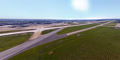 360 degree aerial view of the New Orleans Louis Armstrong International Airport. This photo was taken almost a month after Hurricane Katrina, and three days after Hurricane Rita, which explains why the airport appears virtually deserted except for the hundreds of FEMA trailers lining the runway access roads.
Equipment: NikonD70, Sigma 8mm
Helicopter: Panther Helicopters
Pilot: Lance Panepinto
Categories: Hurricane Katrina
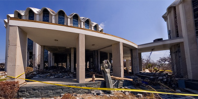
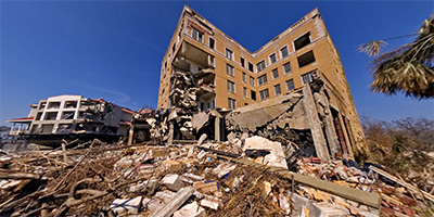 360 degree panorama in front of the historic Tivoli Hotel in Biloxi, MS after Hurricane Katrina. The Tivoli Hotel, built in 1927, and the newer two story Tivoli Motel next door were struck by casino barges that broke free during the 30 foot storm surge. The motel was flattened, killing eight people, and the hotel suffered major damage.
(My first computer job was RPG II programming on an IBM Sys 36 at the Tivoli.)
Equipment: NikonD70, Sigma 8mm, Kaidan QuickPan III
Categories: Hurricane Katrina, World Wide Panorama
 360 degree panorama along Hwy. 90 in Biloxi, MS after Hurricane Katrina, in front of the casino barge that struck the Tivoli Hotel and Motel, killing 8 people.
Equipment: NikonD70, Sigma 8mm, Kaidan QuickPan III
Categories: Hurricane Katrina
 360 degree panorama in the Biloxi Back Bay at the Palace Casino. Katrina’s 30 foot storm surge, the highest ever recorded in America, knocked down walls in the casino parking garage and tossed the Palace Casino barge up on shore. It also finished off the old Hwy. 90 Biloxi-Ocean Springs Bridge, which had been partially destroyed by Hurricane Camille in 1969, but was still intact on the Biloxi side and used as a fishing pier. The truck is a City of Biloxi vehicle.
Equipment: NikonD70, Sigma 8mm, Kaidan QuickPan III
Categories: Hurricane Katrina
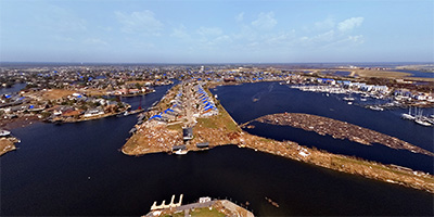
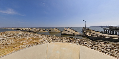 Point Cadet Plaza at the eastern tip of Biloxi, MS, next to the collapsed Biloxi-Ocean Springs Bridge. Nearby is the The Biloxi Fisherman statue by Biloxi sculptor. Look straight down to see where the statue once stood!
(When I lived here people called it either the Mummy or the Creature From The Black Lagoon, which is probably what got the statue moved from the Vieux Marche mall to here.)
Equipment: NikonD70, Sigma 8mm, Kaidan QuickPan III
Categories: Hurricane Katrina
 360 degree panorama after Hurricane Katrina, in front of St Michael’s Catholic Church in Biloxi, across Hwy. 90 from Casino Magic, with a casino barge that washed up next door. St. Michael’s is known as the fisherman’s church and has been the central sponsor of Biloxi’s annual Blessing of the Fleet ceremony.
Equipment: NikonD70, Sigma 8mm, Kaidan QuickPan III
Categories: Hurricane Katrina
 360 degree panorama from Hwy. 90 in Biloxi at Cedar St., across from a casino barge that was tossed ashore. This is across from St. Michael’s Catholic Church, in front of Casino Magic, with Isle of Capri to the east and Grand Casino to the west.
Equipment: NikonD70, Sigma 8mm, Kaidan QuickPan III
Categories: Hurricane Katrina
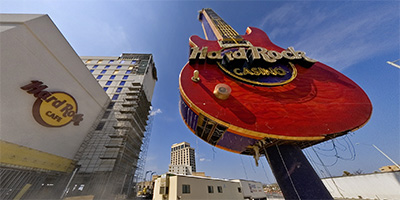 360 degree panorama next to the Biloxi Hard Rock Casino’s giant guitar sign after Hurricane Katrina. As a tribute to Mississippi based musical instrument manufacturer Peavey Electronics, the Biloxi Hard Rock built the largest Hard Rock sign in the world in the shape of a 112’ tall Peavey guitar, and although damaged, it survived Katrina’s 30’ storm surge.
Equipment: NikonD70, Sigma 8mm, Kaidan QuickPan III
Categories: Hurricane Katrina
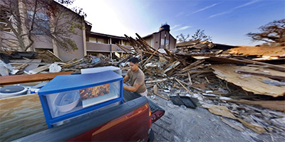 This 360 degree panorama shows a former resident of the Water’s Edge Apartments in Gulfport, MS moving his remaining possessions.
Equipment: NikonD70, Sigma 8mm, Kaidan QuickPan III
Categories: Hurricane Katrina
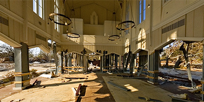 360 degree panorama after Hurricane Katrina showing the inside of St. Peter’s By The Sea Episcopal Church north of Hwy. 90 in Gulfport, MS.
Equipment: NikonD70, Sigma 8mm, Kaidan QuickPan III
Categories: Hurricane Katrina
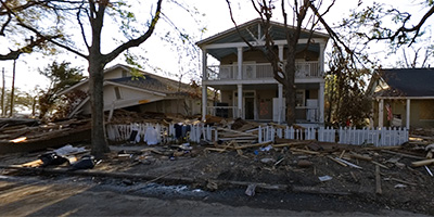 360 degree panorama in Gulfport, MS on 19th Ave. near 15th St. after Hurricane Katrina. Whether knocked flat or still standing, most of these houses are a total loss.
Equipment: NikonD70, Sigma 8mm, Kaidan QuickPan III
Categories: Hurricane Katrina
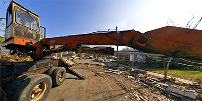 360 degree panorama showing a work crew clearing Hurricane Katrina debris from 19th Ave. near the railroad tracks in Gulfport, MS.
Equipment: NikonD70, Sigma 8mm, Kaidan QuickPan III
Categories: Hurricane Katrina
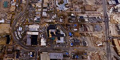
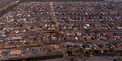
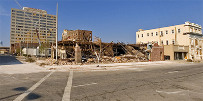
 360 degree panorama of a nearly deserted downtown Gulfport at the intersection of 14th St. and 24th Ave. After Hurricane Katrina everything south of the railroad tracks from Pass Christian to Biloxi was off limits to everyone except property owners and construction crews.
Equipment: NikonD70, Sigma 8mm, Kaidan QuickPan III
Categories: Hurricane Katrina
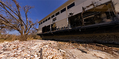
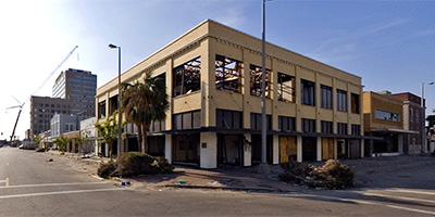
 360 degree panorama after Hurricane Katrina in downtown Gulfport, MS, in front of the Gulf and Ship Island RR Building on 13th St., looking up 26th Ave. toward the Hancock Bank building.
Equipment: NikonD70, Sigma 8mm, Kaidan QuickPan III
Categories: Hurricane Katrina
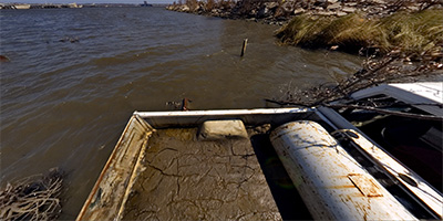
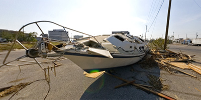 360 degree panorama after Hurricane Katrina, showing the yacht Endorphins washed ashore at 13th St. and 28th Ave. in downtown Gulfport, MS.
Equipment: NikonD70, Sigma 8mm, Kaidan QuickPan III
Categories: Hurricane Katrina

Start with the "Featured" category to see an assortment of my most interesting panoramas.