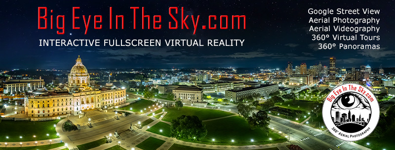
Welcome to BigEyeInTheSky.com
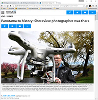
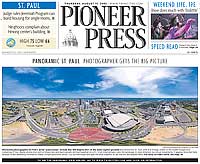
I'm Ed Fink, these are my 360 degree panoramas. I was the first photographer in the world to shoot 360 degree panoramas from a helicopter. Today I'm a FAA licensed drone pilot and shoot most of my aerials with a quadcopter.
In addition to shooting aerial panoramas, I'm also a Google Street View Trusted Photographer in Minneapolis shooting Street View tours inside local businesses.
I publish thousands of 360 degree panoramas and virtual tours to Google Maps, where I currently have over 100 MILLION VIEWS.
Ask me for more information or an estimate for your business!
Facebook - BigEyeInTheSky360
Google Maps - Ed Fink

VISITOR COMMENTS:
"That's the coolest thing on the web."
"You brought tears to my eyes."
"Mind blowing."
"One of the neatest photo sites I've ever seen."
"I'm afraid of heights and when I looked straight down I nearly threw up!"
"I am stunned by the quality and possible applications, nice job."
"That combo of eye-in-the-sky with eyes on the ground is fantastic."
"I sent this to every pilot I know."
"HOW IS THIS EVEN POSSIBLE?!"
"The 360 shots are almost unbelieveable!!!!"
"Oh my gosh Ed - they are just beautiful."
"That aerial panorama over Lake Calhoun is totally awesome"
"FANTASTIC!!!!"
"I've instantly become a fan of your panorama photos!"
"Wow, your panoramas are like nothing I have ever seen before. Very impressive!"
"the absolute best I have seen anywhere."
"ED - I am not surprised by all the comments you have received. The VR is AWESOME!"

Select a panorama category:
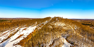
 360 degree aerial panorama above Marquette Mountain Resort, Marquette, MI.
Equipment: DJI Air2s, 22 mm
Categories: Quadcopter, Michigan U.P.
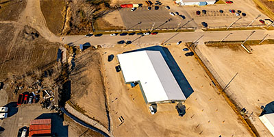
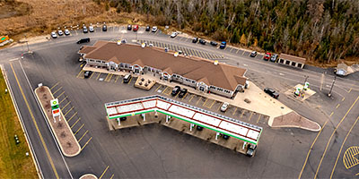
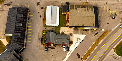
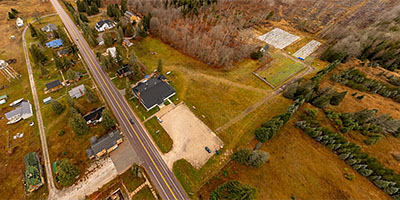 360 degree aerial panorama at 77 North Inc., Germfask, MI.
Equipment: DJI Air2s, 22 mm
Categories: Quadcopter, Michigan U.P.
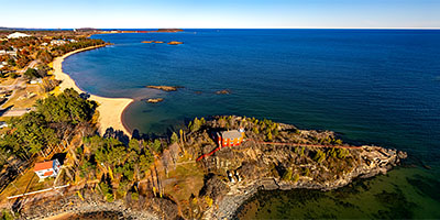
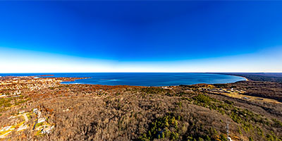
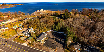
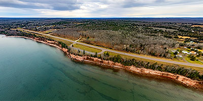 360 degree aerial panorama over Keweenaw Bay, Lake Superior, near Baraga Cliff Roadside Park Michigan.
Equipment: DJI Air2s, 22 mm
Categories: Quadcopter, Michigan U.P.
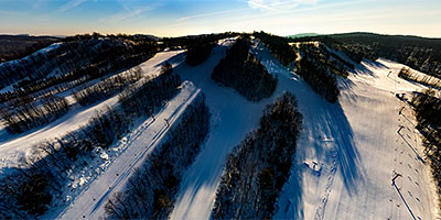 360 degree aerial panorama over the north face of Big Powderhorn Mountain in Ironwood, MI.
Equipment: DJI Air2s, 22 mm
Categories: Ironwood, Quadcopter, Michigan U.P.
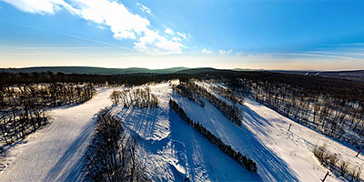 360 degree aerial panorama over the north west face of Big Powderhorn Mountain in Ironwood, MI.
Equipment: DJI Air2s, 22 mm
Categories: Quadcopter, Michigan U.P.
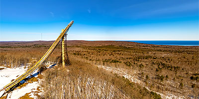 360 degree aerial panorama at Copper Peak Sky Jump in Bessemer, MI. Copper Peak is the largest ski jump in the world. Visitors can take an elevator to the top for the breathtaking view of the Upper Peninsula of Michigan, Lake Superior, the city of Ironwood, and Wisconsin.
Equipment: DJI Air2s, 22 mm
Categories: Quadcopter, Michigan U.P.
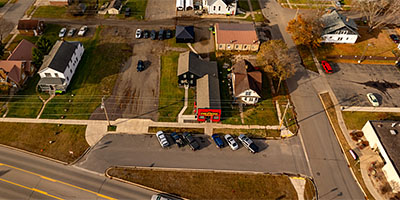
 360 degree aerial panorama Iron County Courthouse in Crystal Fall , MI.
Equipment: DJI Air2s, 22 mm
Categories: Quadcopter, Michigan U.P.
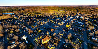
 360 degree aerial panorama at sunrise from Mt. Zion Ski Hill overlooking Gogebic Community College in Ironwood, MI.
Equipment: DJI Air2s, 22 mm
Categories: Quadcopter, Michigan U.P.
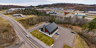
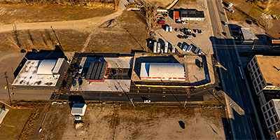
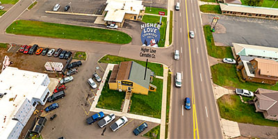 360 degree aerial panorama at Higher Love Cannabis Dispensary in Ironwood, MI. Only a four hour drive from Minneapolis, unless you keep your drone in the back seat and have to stop every half hour to fly!
Equipment: DJI Air2s, 22 mm
Categories: Ironwood, Quadcopter, Michigan U.P.
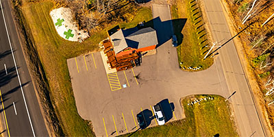
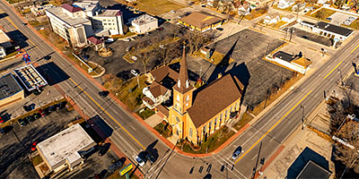 360 degree aerial panorama over Holy Spirit Catholic Church, Menomoniee, MI.
Equipment: DJI Air2s, 22 mm
Categories: Quadcopter, Michigan U.P.
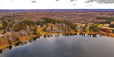 360 degree aerial panorama over Ice Lake, near Lakeshore Motel, in Iron River, MI. Hi Bonnie, I told you I'd do a cool 360 for you!)
Equipment: DJI Air2s, 22 mm
Categories: Quadcopter, Michigan U.P.
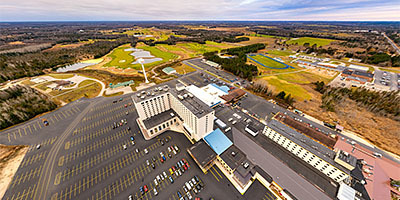 360 degree aerial panorama of Island Resort and Casino, Hannahville. MI.
Equipment: DJI Air2s, 22 mm
Categories: Quadcopter, Michigan U.P.
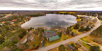 360 degree aerial panorama at Lakeshore Motel on Ice Lake near Iron River, MI.
Equipment: DJI Air2s, 22 mm
Categories: Quadcopter, Michigan U.P.
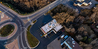
 360 degree aerial panorama near Lume Recreational Cannabis, Menomoniee, MI.
Equipment: DJI Air2s, 22 mm
Categories: Quadcopter, Michigan U.P.
 360 degree aerial panorama at Marinette Inn, Marinette, WI. A freebie because the desk clerk greeted me so nicely late Thanksgiving night, waiting at the door with my key in his hand and a smile on his face.
Equipment: DJI Air2s, 22 mm
Categories: Quadcopter, Michigan U.P.
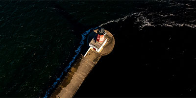
 360 degree aerial panorama at Marquette Harbor Lighthouse, Marquette, MI.
Equipment: DJI Air2s, 22 mm
Categories: Quadcopter, Michigan U.P.
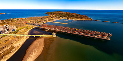
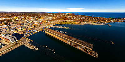 360 degree aerial panorama at Marquette Lower Harbor Ore Docks, Marquette, MI.
Equipment: DJI Air2s, 22 mm
Categories: Quadcopter, Michigan U.P.
 360 degree aerial panorama at Marquette Upper Harbor Ore Docks, Marquette, MI.
Equipment: DJI Air2s, 22 mm
Categories: Quadcopter, Michigan U.P.
 360 degree aerial panorama above Menomoniee Lighthouse, Menomoniee, MI.
Equipment: DJI Air2s, 22 mm
Categories: Quadcopter, Michigan U.P.
 360 degree aerial panorama over 400' above the scenic overlook at Mt. Marquette, Marquette, MI.
Equipment: DJI Air2s, 22 mm
Categories: Quadcopter, Michigan U.P.
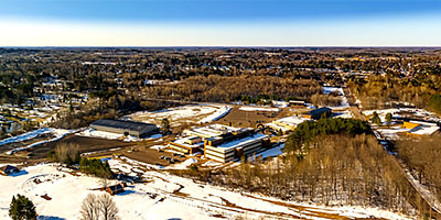
 360 degree aerial panorama at Mt. Zion Ski Hill in Ironwood, MI, a popular destination for skiing and snowboarding enthusiasts in the western Upper Peninsula of Michigan near Gogebic Community College.
Equipment: DJI Air2s, 22 mm
Categories: Quadcopter, Michigan U.P.
 360 degree aerial panorama at Northern Light Cannabis Co, Sault Ste. Marie, MI.
Equipment: DJI Air2s, 22 mm
Categories: Quadcopter, Michigan U.P.
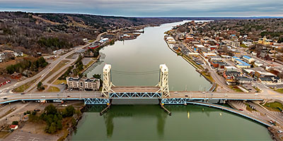 360 degree aerial panorama at Portage Canal Lift Bridge in Houghton, MI.
Equipment: DJI Air2s, 22 mm
Categories: Quadcopter, Michigan U.P.
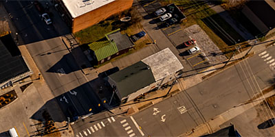
 360 degree aerial panorama caddy-corner from Rize Recreational Cannabis Dispensary, and down the street from Higher Love Cannabis Co. in Ironwood, MI. Only FOUR HOURS drive from Minneapolis!!
Equipment: DJI Air2s, 22 mm
Categories: Featured, Quadcopter, Michigan U.P.
 360 degree aerial panorama at RIZE Cannabis, Menomoniee, MI.
Equipment: DJI Air2s, 22 mm
Categories: Quadcopter, Michigan U.P.
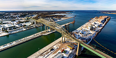 360 degree aerial panorama at Sault Ste. Marie International Bridge, Sault Ste. Marie, MI.
Equipment: DJI Air2s, 22 mm
Categories: Quadcopter, Michigan U.P.
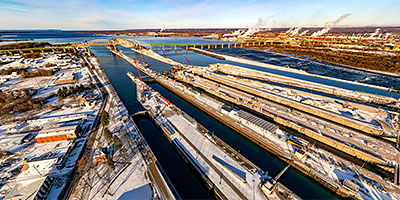 360 degree aerial panorama at Soo Locks, Sault Ste. Marie, MI.
Equipment: DJI Air2s, 22 mm
Categories: Quadcopter, Michigan U.P.
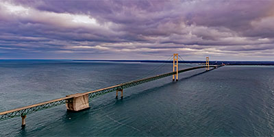 360 degree aerial panorama over the Straits of Mackinac near the Mackinac Bridge in Michigan.
Equipment: DJI Air2s, 22 mm
Categories: Quadcopter, Michigan U.P.
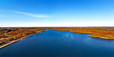 360 degree aerial panorama over Teal Lake in Negaunee, MI.
Equipment: DJI Air2s, 22 mm
Categories: Quadcopter, Michigan U.P.
 360 degree aerial panorama above The Fire Station Cannabis Co. Hannahville. MI.
Equipment: DJI Air2s, 22 mm
Categories: Fire Station Cannabis Co., Quadcopter, Michigan U.P.
 360 degree aerial panorama above The Fire Station Cannabis Co., Houghton, MI.
Equipment: DJI Air2s, 22 mm
Categories: Fire Station Cannabis Co., Quadcopter, Michigan U.P.
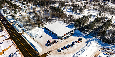
 360 degree aerial panorama above The Fire Station Cannabis Co., Iron River, MI.
Equipment: DJI Air2s, 22 mm
Categories: Fire Station Cannabis Co., Quadcopter, Michigan U.P.
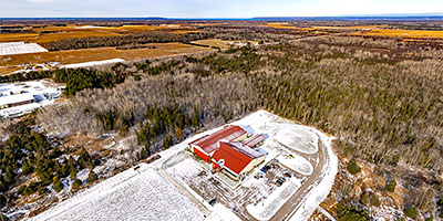
 360 degree aerial panorama above The Fire Station Cannabis Co., Ishpeming, MI.
Equipment: DJI Air2s, 22 mm
Categories: Fire Station Cannabis Co., Quadcopter, Michigan U.P.
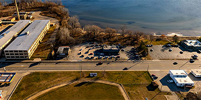
 360 degree aerial panorama above The Fire Station Cannabis Co., Marquette, MI.
Equipment: DJI Air2s, 22 mm
Categories: Fire Station Cannabis Co., Quadcopter, Michigan U.P.
 360 degree aerial panorama at The Fire Station Cannabis Co., Menomoniee, MI.
Equipment: DJI Air2s, 22 mm
Categories: Fire Station Cannabis Co., Quadcopter, Michigan U.P.
 360 degree aerial panorama above The Fire Station Cannabis Co., Munising, MI.
Equipment: DJI Air2s, 22 mm
Categories: Fire Station Cannabis Co., Quadcopter, Michigan U.P.
 360 degree aerial panorama above The Fire Station Cannabis Co., Negaunee, MI.
Equipment: DJI Air2s, 22 mm
Categories: Fire Station Cannabis Co., Quadcopter, Michigan U.P.
 360 degree aerial panorama above The Fire Station Cannabis Co., Sault Ste. Marie, MI.
Equipment: DJI Air2s, 22 mm
Categories: Fire Station Cannabis Co., Quadcopter, Michigan U.P.
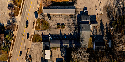
 360 degree aerial panorama at Weed World Adult Arcade, Marquette, MI.
Equipment: DJI Air2s, 22 mm
Categories: Quadcopter, Michigan U.P.
Start with the "Featured" category to see an assortment of my most interesting panoramas.