360 Degree Panoramas © Edward S. Fink for BigEyeInTheSky.com
This content requires Adobe Flash Player 10 and a browser with JavaScript enabled.
Built on Flash Panorama Player.
Built on Flash Panorama Player.
35W Bridge Collapse
360 degree panoramas of the collapsed I-35W bridge over the Mississippi River in Minneapolis, Minnesota. Includes photos of the new bridge too.
This page of the 35W Bridge Collapse virtual tour includes the following 360 degree panoramas:
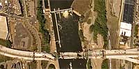 360 degree aerial panorama over the collapsed I-35W bridge spanning the Mississippi River in Minneapolis, MN.
This was shot the morning after the collapse when there was a TFR (temporary flight restriction) over the bridge, and I had to fly significantly higher than I normally shoot, so you won’t be able to see much detail in the bridge. I may be able to do more at a decent altitude when the TFR is lifted.
Equipment: Nikon D70s, Sigma 8mm, PocketWizard Plus
Helicopter: Davis Aviation
Pilot: Joanne Boyer